

Supporting Services
- Traffic & Transportation Studies
- Soil mechanics and foundation engineering
- Route Selection
- Assistance to Clients for Contractor Claim Evaluation
- Construction Assistance
- Quantity Surveying and Cost Estimates
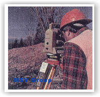
Surveying Services
SURVEYING is a critical first step in a project’s life. In our surveying practice, we value accuracy and timeliness. We ensure that our survey crews and technicians keep pace with ever changing technology, and we provide them with the most advanced equipment. That’s why we have invested in technologies such as Global Positioning System (GPS) equipment, which uses satellites to produce the fastest and most accurate results available today. We have made use of the satellite imagery.
All types of surveying services are provided for highways, bridges, railways, rivers and other water bodies, airports, harbors, recreation sites, industrial site, commercial sites, residential sites, mines and pipelines.
High-tech equipment and continuing education help us retain good people and provide the level of service and accuracy our clients expect.
- ALTA/ASCM Surveys
- Base Mapping
- Boundary Surveys
- Cadastral Surveys
- Construction Surveys
- Control Surveys
- Field-to-Finish Mapping
- GPS Surveys
- Hydrographic Surveys
- Mapping Services
- Platting Topographic Surveys
- Mine Surveys
- As-Built Surveys

EQUIPMENT
- Wild T-2000 series theomats with distance meters and data collectors
- Trimble Navigation Static and Kinematic GPS Receivers
- 30-foot survey vessel with real-time integrated system for automated hydrography
- Racal Micro-Fix Positioning System
- Fully integrated computer and plotting systems to provide fast, accurate survey results.
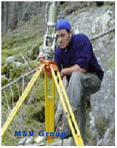
GLOBAL POSITIONING SYSTEM (GPS) SURVEYING
When you need accuracy quickly – GPS surveying provides it. GPS technology establishes the relative position of survey control points to centimeter-level accuracy within minutes. We call it cost-effective technology. Both kinematic and static GPS are important elements of our field-to-finish mapping services.
We have provided GPS surveying services since 1987, and our surveyors are seasoned professionals. They research data; collect precise field measurements; and perform intense network design, analysis, and least squares adjustments.
GPS SERVICES
- Cadastrial Control
- Control for Photogrammetric Mapping
- Geodetic base information for a Geographic Information System (GIS) or Land Information System (LIS)
- Hydrographic Positioning
- Kinematic GPS
- Offshore Positining
- Route Surveys
- Subsidence Monitoring
- Three Dimensional Control Surveys
- Urban and Suburban Control Networks
EQUIPMENT
- Kinematically-capable Trible Navigation 4000 SX and 4000 ST receivers
- Precise Centering and Reading Kern Tripods
- Compaq Computers
- Geolab Adjustment Software
- Four-wheel drive (radio-equipped) vehicles assigned with each receiver.
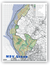
GEOGRAPHIC INFORMATION SYSTEM (GIS)
Our aim is to help you organize, analyze, manage, and express complex ideas involving land, buildings, infrastructure, population, or natural resources. With GIS technology, we offer a full range of mapping and information management services to assist you in achieving your objectives.
We apply GIS technology daily to a variety of projects. We have learned the strengths and weaknesses of this new technology and how to access the information our clients need to make informed decisions.
GIS SERVICES
- Computerized Mapping Needs assessment
- GIS database design and implementation
- Automated mapping (AM)
- Pilot Studies and Prototypes
- Data Conversion
- Electronic Transfer of GPS field coordinates into CADD and GIS
- Parcel Digitizing
- AML and LISP Program Development
- Custom menu query system development
- Development of system interface programs
- Development of user manuals and other documentation
- Ongoing mapping and database maintenance
- Computer Aided Drafting and Design (CADD)
- ARC/INFO Workstations
- Intergraph Workstations
- AutoCAD Map Workstations
- AutoCAD Workstations
- IBM Compatible personal computers running WILDsoft, ARC/INFO, AutoCAD, DCA, LandCADD, Intergraph Microstation and in-house developed softwares.
- Summagraphic Digitization Tables
- Hewlett Packard Pen and Calcomp Electrostatic Plotters
Value Engineering
To help the client with critical decisions that affect long-term results, MSV offers front-end planning, Project management consultancy services. These are provided by planners, engineers, economists, sociologists, scientists, technicians and specialists in operations, real estate and finance, and are focused on minimizing expenditures and maximizing operational profits.
